


Infrastructure
Peachtree Trail was an early Indian road from the heart of the Cherokee Nation to the Creek Indian Village of Standing Peachtree. Later called Dixie Highway, now called
U.S. Highway 41.
Paces Ferry Road is where the governor’s mansion is located. The original road here was named after Hardy Pace (1785-1864), who ran a ferry across the Chattahoochee River in the 1830s on the route to what is now Vinings. Pace was a pioneer from N. C. who came in the 1820s and built a house on what is now Paces Ferry Road. A post office was established in the 1830s until April 16, 1839 when Hardy Pace moved to Vinings, changing the name of the PO to Cross Roads. Shortly after this, the present Vinings Mountain was given the name Pace’s Mountain, after Pace built a house at the foot of it.
Jan. 30, 1899
Chattahoochee Bridge Afire
Western and Atlantic Railroad in Danger
The Western and Atlantic Railroad bridge over Chattahoochee River caught fire yesterday morning, and, but for the hard work of three Atlanta men, would have been consumed by the flames.Yesterday morning about 9:30 o'clock Mr James D. Collins, Mr. Alphonso Shields and Mr. Hugh Woodruff while investigating some land near Bolton, discovered that the Chattahoochee railroad bridge was burning. By carrying water from the river in a bucket and in their hats, they succeeded in extinguishing the flames after a half hour's hard work.
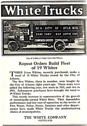
1919 Advertisement

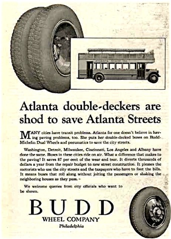 1926 Advertisement
Feb. 13, 1876

Peachtree Street
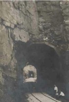 Atlanta Tunnel 1912
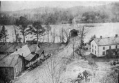
Covered Bridge over Chattahoochee River
Roswell Ga. ca. 1900
Bankhead Highway is U.S. Highway 78 between Atlanta Ga. and Birmingham Ala. Believed named for William Brockman Bankhead (1874-1940) of Alabama, who served in the U. S. Congress (1917 - 1940).
Collier Road was named for Andrew J. Collier (1827-1887) who built a grist mill on Tanyard Branch.
Cox”s Crossroad was the early name of the intersection of Moore’s Mill and Howell Mill roads. Named for Carr Cox, who was postmaster in 1881 of Howell’s Mill post office.

The Perimeter, goes through Fulton, Cobb, DeKalb, and Clayton Counties. The descriptive name given to U. S. highway I285 which encircles metropolitan Atlanta. It opened in 1970, and has also been called The Loop.

![ACTS AND RESOLUTIONS OF THE GENERAL ASSEMBLY OF THE STATE OF GEORGIA 1937
PART I.--GENERAL PUBLIC LAWS
TITLE VIII. HIGHWAYS OF THE STATE.
Page: 993
Fulton County line; thence following along or near the Old Fairburn-Ben Hill Road (connecting, and crossing the Byrum Highway at Ben Hill) to the Gordon Road, connecting same at Adamsville; thence following along Gordon Road to the Bolton Road; thence following along, or near the Bolton Road (connecting, and crossing State Route No. 8 at Mayson's Church) to the Marietta Road, State Route No. 3, intersecting same in Bolton. Approximate length of this link 17.0 miles.
[Sidenote: Roosevelt Highway to Bolton.]
(2) A link in belt highway, leading northeast from State Route No. 3 in Bolton, following along Chattahoochee Avenue to Moore's Mill Road; thence following along, or near Moore's Mill Road (connecting, and crossing new Atlanta-Marietta Road) to Paces Ferry Road; thence following along Paces Ferry Road to Buckhead, connecting State Routes Nos. 9 and 13. Approximate length of this link 4.5 miles.
[Sidenote: Bolton to Buckhead.]](Infrastructure_files/shapeimage_2.png)


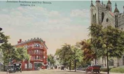
Junction Peachtree Street & Ivy Street
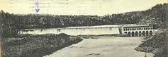
Bull Sluice is located about six miles below Roswell on the Chattahoochee River. This shoal was given its name by the Cherokee Indians. It was later changed to Morgan Falls.
Bull Sluice - 1903 - above

The Atlanta Water Works moved from its original location on the South River to the Chattahoochee River in 1893. The pumping station, which is just north of Bolton, is linked by a network of pipelines to the reservoirs that are located in the southeast corner of NPU-D. The Hemphill Plant was built to serve as a water treatment facility. One early settler, Thomas Moore, whose residence was at the intersection of DeFoors Ferry Road and Chattahoochee Avenue, donated part of his vast estate to form the right-of-way for the water mains. Blandtown developed near the reservoirs, as housing for employees of the Atlanta Water Works.

The Chattahoochee River supplies 70% of metro Atlanta’s drinking water, which is more than 300 million gallons per day. The headwaters above Atlanta comprise the smallest watershed providing a major portion of water supply for any metropolitan area in the country.
The Beltline Emerald Necklace:
Atlanta’s New Public Realm
Opportunities
Waterworks
204 acres
Reservoirs have long been used as settings for public parks. At the end of the 19th century, Frederick Law Olmsted created such a park around the Brookline Reservoir in suburban Boston. In the fall of 2004, a running path around the reservoir was opened to the public. One of New Yorkers’ favorite places to jog and stroll is the Central Park Reservoir. The Atlanta Waterworks on Howell Mill Road could be used in a similar manner. Constructed in 1892 on the highest point of land between central Atlanta and the Chattahoochee River, the reservoir was described in a contemporary newspaper account as “designed to have a magnificent summer pavilion on the hill just overlooking the reservoir from the north and the thirty acres of land surrounding it, which is owned by the city, will be used as a park…” The base of the pavilion still exists, but unfortunately, the entire site is restricted from public access. Atlanta must reclaim this magnificent jewel, and add it to the Beltline Emerald Necklace. The major challenge of returning the Waterworks reservoir to its historic role as a lakeside park on a hilltop is the security of Atlanta’s water supply. When built, the
reservoir held over 200 million gallons of water and protected the city’s water supply from interruptions due to mechanical failure or temporary impurity of its source at the Chattahoochee. Its capacity has been enlarged over the years, most recently in the 1990s. Now its main vulnerability is sabotage, and for that reason the entire property is
surrounded by high fencing that restricts access. A creative design analysis may determine that an effective and more attractive barrier—like the handsome wrought iron fence around the Central Park Reservoir—will enable user access once again. Thereby, the land surrounding the Waterworks could be reopened to public use as the barrier is moved closer to the edge of the reservoir. The recovered land could then be made inviting, and if at any time in the future the basins themselves are no longer needed, the fence can be removed and two wonderful lakes opened to public use. Whether or not the lakes become available for public use, reopening of the parkland would trigger rapid redevelopment of adjacent commercial buildings and derelict residential structures.
Bellwood Lake
Estimated 579 acres (434 acres of open space)
Piedmont Park (185 acres) and Grant Park (127 acres) are precious jewels among Atlanta’s parks. While both are exceeded in size by Freedom Park (197 acres), they provide better recreation opportunities than any other facility in the city. Wonderful as Piedmont Park and Grant Park may be, Atlanta should have more than two great parks, both of which happen to be on the east side of town. Fortunately, the west side of Atlanta features a series of properties that can be assembled into another great park. A great park such as Piedmont Park or Grant Park has three characteristics: it is a
regional destination that draws users from beyond the adjacent area, thus becoming an icon for the city; it increases the strength of the adjacent communities, thus increasing the quality of life for residents; and it increases the long-term quality and value of the adjacent residential areas, thereby increasing the city’s tax base. The new Bellwood Park—the largest and most ambitious Beltline Jewel—will succeed in joining Piedmont Park and Grant Park on Atlanta’s short list of great parks. In order to do so, the following actions must occur:
• Convert the Bellwood Quarry into a lake and new park
• Develop a new community around the Bellwood Lake Park
The Bellwood Quarry and its adjacent properties consist of 579 acres just north and west of the Bankhead MARTA station. Perry Boulevard and Johnson Road bounds the properties to the north, and Marietta Boulevard bounds the properties to the east. The Perry-Bolton Tax Allocation District, which has generated the Perry Homes development directly to the west of the site, slightly overlaps the western boundary of this future park. The West Highlands Development, which has dedicated a significant amount of open space, is located in the northwest section. Otherwise, the land is largely undeveloped with the exception of the quarry and the Georgia Power lines that run northwest through the site. The PATH Foundation is finalizing plans to run a trail along these power lines. This trail would provide a key connections from the Beltline Trail to both downtown Atlanta and the Silver Comet Trail which will eventually extend
all the way to Alabama. Finally, the Beltline Transit will share the MARTA Bankhead Station in the southeast corner of the site. The properties within the new park’s boundaries will be far more valuable after the Maddox Park expansion and Simpson Road development to the south and the Perry-Bolton development to the west. At that time, the quarry’s continued use as a source of stone and gravel will no longer be cost-effective. The deep excavations in the site are not easy to develop for residential use, but they are ideal for transformation into a splendid lake that would provide the residents of the city with wonderful opportunities to sail, kayak, canoe, and fish. In addition, the property is large enough to provide peripheral sites for housing development that will subsidize the cost of converting the land into park use and maintaining it after completion. Currently, the Vulcan Materials Company holds a lease on the property which is owned by Fulton County. The lease expires in 2034. Even if Atlanta must wait 30 years before this park can be realized, the wait would be worthwhile. The quarry’s conversion to an expansive public park focused around a new lake is too great an opportunity to miss. The pace of development in the west side, however, will greatly increase the value of the quarry’s lease. Consequently, an arrangement to buy out the remaining term of the existing lease will become realistic long before 2034. A key design feature to Bellwood Lake Park will include a linear park that extends all the way from the new transit station at Simpson Road through Maddox Park and the Bankhead MARTA station into Bellwood Lake Park. From Bankhead Boulevard, the linear open space will include a parallel parkway that extends around Bellwood Lake and
through Perry Boulevard on the northern boundary. The new lake and surrounding park will make the territory particularly attractive for new residential development. However, real estate developers too often build directly on the edge of an attractive waterfront. These houses usually hide the lake from public view and often preclude public access.
Such conditions will not occur in Bellwood Lake Park. Instead, pedestrian paths, jogging trails, bicycle paths, and vehicular roadways will frame the lake, and residential development will occur on the outside of the network of roads framing the park. Thus, Atlantans visiting the new park will have the pleasure of seeing the lake and the large expanses of open space as they stroll, jog, or ride near by. This approach to development also has a financial rationale. A wider and longer perimeter of roadways encircling the new park creates more lakefront sites and thus greater revenues from sales than would have been available from the smaller number of sites that would have direct views of the lake.
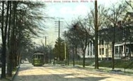
Capitol Ave. looking N 1920

The condition of the streets of Atlanta before the war is sufficiently described
by extracts from the newspapers published during that period.
The following extract from the Daily Intelligencer of Feb. 19, 1852,
will serve to give some idea of the condition of the streets of Atlanta,
at the time of its publication:
“A Word to Strangers”
If you arrive in town on any of the numerous railroads that terminate here, it will probably be just before dark. After refreshing yourselves with a hearty meal at some of our well conducted hotels, you will feel a desire to take a stroll about town, at least through Whitehall Street. Starting from the vicinity of the railroads you can proceed fearlessly till you come to the first cross street, called Alabama Street. Don’t think of walking out of your direction to walk up that street unless the moon shines particularly bright, or unless you can hang to the coat tail of some friendly guide; as without such aids you wold probably find yourself in about two minutes at the bottom of a pit., fifteen feet in diameter by eighteen feet deep, which occupies the center of the road, and thus occasion considerable trouble to those who happen to be near, in procuring ropes to drag you out, and in such case, you might besides, be inclined to form an unfavorable impression in regard to our city regulations, as did a gentleman last week, who was hauled out of the pit pretty severely injured.
Passing this point you can continue in Whitehall Street, but by all means take the right hand side, as on the left side are two deep trenches dug out for cellars. We are not informed whether the cellar doors are built, or whether they are intended o extend to the center of the street or only across the sidewalk. At present they are admirably adapted to catch unwary passengers. In one night last week, during a rain storm, they caught no less than five - two ladies and three gentlemen, returning from a concert. One of these was a stranger in the city, and while spreading himself before a blazing fire, in the Holland House, to dry the red clay with which his garments were beautifully covered, gave way so much to his feelings that he was observed very much upset at the mention of our venerable city council.
“ Proceeding on the right hand side of the street you will have a very comfortable walk until you come to Cook’s corner, where the pavement ceases. Here you had better turn square round and walk back, for directly in advance is another pit, fifteen by eighteen feet, ready to take you in. In some parts of the town we believe these holes have been covered over. The one in front of Loyd & Perryman’s store, where a man fell in and broke his neck some weeks since, we are credibly informed was promptly covered after the event.”
“P.S. -- Since the above was put in type we are gratified and delighted that each of the pits mentioned above, have been temporarily covered with plank so as to avoid the recurrence of further accidents.”

City Utilities Committee
Agenda
May 27, 2008
08R1031 ( 3)
A resolution by City Utilities Committee authorizing the Mayor to enter into an agreement which authorizes the Norfolk Southern Railway Company to install a new Hollywood Road bridge above the railroad’s right of way that runs below Hollywood Road between Perry Boulevard and Burtz Street, to relocate a Department of Watershed Management Water Main running across the surface of the present bridge, to cause the City to assist, if necessary in the permanent acquisition of easements to permit the installation of traffic control devices along the temporary detour route to be used during bridge construction, to require the railroad to deliver to the City a new easement over the railroad’s property under the Hollywood Road bridge; and for other purposes.

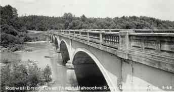
Roswell Bridge over Chattahoochee River
US 19 Roswell Ga.
Postcard marked March 23, 1964
A curious incident of the Terminus part of Atlanta’s history was that in settling the town the neighboring cows were in the habit of wending their way to the central spring for water. These cow paths broadened into roads and finally crystalized into streets. The surrounding neighborhoods, was poor people, living in log cabins with dirt floors, and having few of even the necessities of life. It will thus be seen that Atlanta had a very humble beginning. And thus the cows were responsible for laying off the plan of Atlanta. But the place is none the less attractive for that irregularity, and Peachtree St., which twists out, is probably one of the finest streets on the American continent, and deservedly celebrated for its beauty.