

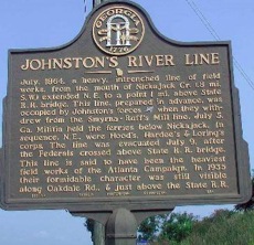
Johnston’s River Line
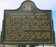
JOHNSTON’S ARMY
CROSSED THE RIVER
July 5-9, 1864. Johnston’s Army of Tenn. held a fortified line N. of the Chattahoochee from Nickajack Cr. To one mile above Peachtree Cr, Federal crossings several miles upriver July 8, making the line untenable, Johnston crossed his force July 9 to this side on 5 bridges: a traffic bridge here: the State R.R. bridge and 3 pontoon bridges downstream.
Until Federal movements from upriver crossings to Peachtree Cr. Valley became evident, Johnston’s force marked time here until the 18th when they were placed in the outer defense line of Atlanta N. and E. of the city.
060-85 Georgia Historic Marker 1985
Location: Waterworks gate off Bolton Rd (at Nixon), Bolton
LATITUDE 33.8212224988
LONGITUDE -84.460150487
County: Fulton
July, 1864, a heavy, intrenched line of field works, from the mouth of Nickajack Cr. (.8 mi. S. W.) extended N. E. to a point 1 mi. above State R. R. bridge. This line, prepared in advance, was occupied by Johnston's forces [CS] when they withdrew from the Smyrna - Ruff's Mill line, July 5. Ga. Militia held the ferries below Nickajack. In sequence, N. E., were Hood's, Hardee's & Loring's corps. The line was evacuated July 9, after the Federals cross above State R. R. bridge. This line is said to have been the heaviest field works of the Atlanta Campaign. In 1935 their formidable character was still visible along Oakdale Rd., & just above the State R. R.
033-72 GEORGIA HISTORICAL COMMISSION 1954
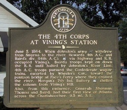
June 5, 1864. When Johnston's army [CS] withdrew from Smyrna to the river, Howard's 4th A. C., and Baird's div. (14th A.C.), [US] via highway and R. R. occupied Vining's. Baird's troops kept on down the R. R. until halted by Johnston's River Line. 4th A.C. troops pursued the Confederate wagontrains, escorted by Wheeler's Cav., toward the pontoon bridge at Pace's Ferry where they crossed the river. Morgan's 7th Ind. Battery [US] shelled the column from Vining's Hill.
Also, from this eminence, Generals Sherman, Thomas and Baird, had their first view of Atlanta, across the Chattahoochee, 9.5 mi. S. E.
GHM 033-83 GEORGIA HISTORIC MARKER 1988
Located on the north side of Paces Ferry Rd. at the old railroad station in Vining's.
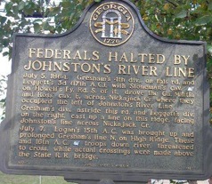
FEDERALS HALTED BY JOHNSTON'S RIVER LINE
July 5, 1864. Gresham's 4th div., on this rd. and Leggett's 3d (17 A. C.), with Stoneman's cav. [US] on Howell's Fy. Rd. S. of it, drove the Ga. Militia and Ross' cav. E. across Nickajack Dr. where they occupied the left of Johnston's River Line.
Gresham's div., astride this rd. and Leggett's div. on the right, cast up a line on this ridge, facing Johnston's line across Nickajack Cr.
July 7. Logan's 15th A. C. was brought up and prolonged Greshman's line N. on High Ridge. These and 16th A. C. [US] troops down river, threatened to cross, while actual crossings were made above the State R. R. bridge.
033-71 GEORGIA HISTORIC MARKER 1987